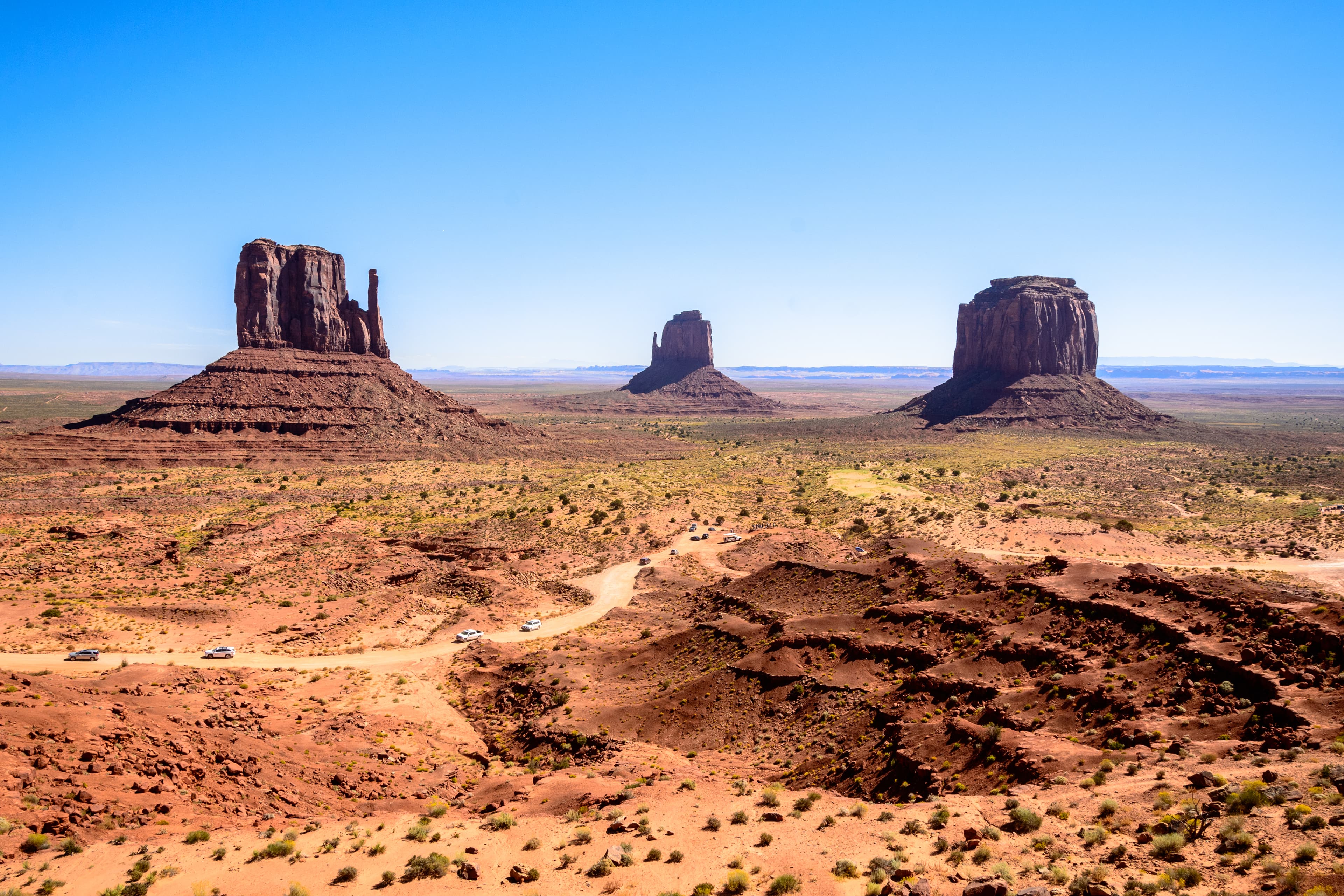
American Southwest
United States

Lake Atitlán
Guatemala
American Southwest
Lake Atitlán
💰 Budget
🛡️ Safety
American Southwest
The Southwest's gateway towns (Sedona, Flagstaff, Page, Williams) have low crime rates. The real risks are environmental: extreme heat, flash floods, altitude sickness on the rim, dehydration, and long distances between services. More national-park visitors die from heat and falls here than anywhere else in the system.
Lake Atitlán
Lake Atitlán itself is generally safe for travelers and is visited by hundreds of thousands of tourists annually. The main safety concerns are practical rather than violent: the Xocomil afternoon winds can make lancha crossings dangerous, occasional petty theft occurs in Panajachel, and chicken bus routes between towns have historically had sporadic robberies. The San Pedro La Laguna party scene has a drug presence and warrants situational awareness at night. The overall experience is safe when basic precautions are taken.
⭐ Ratings
🌤️ Weather
American Southwest
The American Southwest spans a huge elevation range — from desert floors at 900 meters to canyon rims above 2,500 meters — so weather varies dramatically. Low deserts (Phoenix, Page) bake in summer (40°C+), while Grand Canyon South Rim and Flagstaff can get snow in winter. Sedona sits in between. The July-September "monsoon" brings sudden, violent thunderstorms and flash floods.
Lake Atitlán
Lake Atitlán has a highland subtropical climate that is pleasant year-round, with temperatures typically ranging from 15-25°C (59-77°F). The lake's elevation prevents the oppressive heat of Guatemala's Pacific lowlands. There are two distinct seasons: a dry season from November to April with clear skies and cool nights, and a wet season from May to October with warm mornings and heavy afternoon thunderstorms that typically clear by evening. The lake is famous for its afternoon winds — the Xocomil — which sweep across the water from the south and can create rough chop that suspends lancha service.
🚇 Getting Around
American Southwest
A rental car is essentially mandatory to explore the Southwest. Distances are huge (Grand Canyon to Monument Valley is 280 km; Sedona to Page is 210 km) and public transport between parks is minimal. Once inside Grand Canyon South Rim, however, free shuttle buses efficiently cover all viewpoints. Amtrak's Southwest Chief stops at Flagstaff, and small regional airports serve the area.
Walkability: Downtown Sedona, Flagstaff, Williams, and Page are pleasantly walkable once you've parked. The Grand Canyon Village is very walkable — you can walk the entire South Rim Trail (21 km) past all major viewpoints. Outside town centers, distances and lack of sidewalks make walking impractical.
Lake Atitlán
Lake Atitlán is connected internally by an extensive network of public lanchas (motorboats) running between the 12 lakeside villages. Within each village, tuk-tuks (three-wheeled auto-rickshaws) provide inexpensive local transport. Chicken buses connect villages on the road network to Panajachel and up to Sololá. The lake's geography means boats are almost always faster than road routes for inter-village travel.
Walkability: Individual villages are very walkable — San Pedro, San Marcos, and San Juan are all compact enough to explore entirely on foot. Panajachel's Calle Santander is the main commercial street and is pedestrian-friendly. However, the steep terrain in most villages means significant uphill walking; good shoes are essential.
The Verdict
Choose American Southwest if...
you want Grand Canyon vistas, Sedona red rocks, Antelope Canyon light shafts, and the great American road trip through red-rock country
Choose Lake Atitlán if...
you want a volcano-rimmed Maya highland lake — twelve villages each with its own character, lanchas between them, and Spanish-school + yoga options
American Southwest
Lake Atitlán