American Southwest vs Yosemite National Park
Which destination is right for your next trip?
American Southwest
United States

Yosemite National Park
United States
American Southwest
Yosemite National Park
💰 Budget
🛡️ Safety
American Southwest
The Southwest's gateway towns (Sedona, Flagstaff, Page, Williams) have low crime rates. The real risks are environmental: extreme heat, flash floods, altitude sickness on the rim, dehydration, and long distances between services. More national-park visitors die from heat and falls here than anywhere else in the system.
Yosemite National Park
Yosemite is safe from a crime perspective — property crime in parking lots is the main concern. The real hazards are natural: fatal falls on Half Dome and other high-exposure granite, drownings in the Merced River (especially Emerald Pool above Vernal Fall), rockfall, black bears raiding cars and campsites, lightning at altitude, and wildfire smoke. Yosemite averages 12-15 fatalities per year — the highest of any US national park by total count — primarily from falls and drownings. The Merced River kills multiple visitors every year. Emerald Pool above Vernal Fall looks like a swimming hole but is fed by the slick granite above Nevada Fall, and people regularly slip in and get swept over the 317-foot drop. Signs posted along the river reading "IF YOU GO OVER THE FALLS YOU WILL DIE" are not hyperbole. Half Dome's cables have killed hikers caught in thunderstorms — wet granite plus lightning is not survivable on that slope. The 2017 Royal Arches rockfall killed a climber and reminded everyone that the valley's granite walls still drop rock without warning. Black bears in the valley are highly habituated; food in a car overnight will almost certainly be broken into unless it's in a bear locker.
⭐ Ratings
🌤️ Weather
American Southwest
The American Southwest spans a huge elevation range — from desert floors at 900 meters to canyon rims above 2,500 meters — so weather varies dramatically. Low deserts (Phoenix, Page) bake in summer (40°C+), while Grand Canyon South Rim and Flagstaff can get snow in winter. Sedona sits in between. The July-September "monsoon" brings sudden, violent thunderstorms and flash floods.
Yosemite National Park
Yosemite has a Mediterranean-to-alpine climate that is dominated by elevation. Yosemite Valley sits at roughly 4,000 feet — warm dry summers, cool wet winters with occasional snow. The high country around Tuolumne Meadows (8,600 ft) and Tioga Pass (9,943 ft) runs roughly 10°C / 18°F cooler than the valley on any given day and stays under deep snow from November through May. This elevation split means you can be in shorts in the valley and a parka two hours later. Summers in the valley are classic California — blue skies, afternoon temperatures in the high 20s Celsius, cool nights, and very little rain. Thunderstorms build in the high country most afternoons, especially in July and August, and can hit Half Dome's exposed granite cables without warning. Spring is the waterfall peak — May is the single best month for Yosemite Falls — and fall brings crisp days, turning aspens in Tuolumne Meadows, and the occasional smoky day from California wildfires farther west. Winter is spectacular in the valley but demands planning: tire chains are frequently required on park roads (posted as R1/R2/R3 restrictions), Tioga Road and Glacier Point Road close completely, and Badger Pass ski area operates mid-December through March. The valley itself rarely drops deep below freezing at night and often sees dustings of snow rather than heavy accumulation. Photographers covet the stretch from late December through February for frozen waterfalls and snow-rimmed granite.
🚇 Getting Around
American Southwest
A rental car is essentially mandatory to explore the Southwest. Distances are huge (Grand Canyon to Monument Valley is 280 km; Sedona to Page is 210 km) and public transport between parks is minimal. Once inside Grand Canyon South Rim, however, free shuttle buses efficiently cover all viewpoints. Amtrak's Southwest Chief stops at Flagstaff, and small regional airports serve the area.
Walkability: Downtown Sedona, Flagstaff, Williams, and Page are pleasantly walkable once you've parked. The Grand Canyon Village is very walkable — you can walk the entire South Rim Trail (21 km) past all major viewpoints. Outside town centers, distances and lack of sidewalks make walking impractical.
Yosemite National Park
Yosemite is one of the very few US national parks where you can genuinely arrive and get around without a car — a rare enough claim that it's worth emphasizing. YARTS (Yosemite Area Regional Transportation System) runs scheduled buses into the park from four gateway regions, connecting with Amtrak at Merced and functioning as real public transit rather than a tour bus. Inside Yosemite Valley, a free year-round shuttle loops every 10-20 minutes between the 21 major stops — lodges, trailheads, villages, and campgrounds — and in peak summer the valley is essentially a pedestrian-and-shuttle zone rather than a drive-through. For visitors coming from San Francisco, the budget route is genuinely competitive: take Amtrak from Emeryville (connected to SF by bus) to Merced (3 hours), then YARTS into the valley (2.5 hours). Total cost is often USD 60-90 each way and avoids the parking nightmare and summer entry reservation system that plague car arrivals. For visitors who want to see the whole park (Glacier Point, Mariposa Grove, Tioga Road, Hetch Hetchy), a car becomes much more useful — YARTS only covers the main park corridors and doesn't serve the Glacier Point Road or Tioga Road high country. Inside the valley, the free shuttle is genuinely essential in summer — the parking lots at trailheads fill by 8-9am and the shuttle lets you hop between, say, Happy Isles (for Mist Trail) and Yosemite Falls without moving your car. A seasonal Glacier Point shuttle runs from the valley in summer for those without cars. There is no Uber or Lyft coverage inside the park. Cell service is spotty in the valley and absent in most of the park.
Walkability: Yosemite Valley itself is walkable and shuttle-friendly — lodges, restaurants, visitor center, and major trailheads are all within a 2-mile radius connected by paved paths and the free shuttle. Outside the valley, distances and terrain make walking between sights impractical; Mariposa Grove is a 1-hour drive south and Tuolumne Meadows is a 1.5-hour drive east. There is no rideshare (Uber/Lyft) coverage inside the park.
The Verdict
Choose American Southwest if...
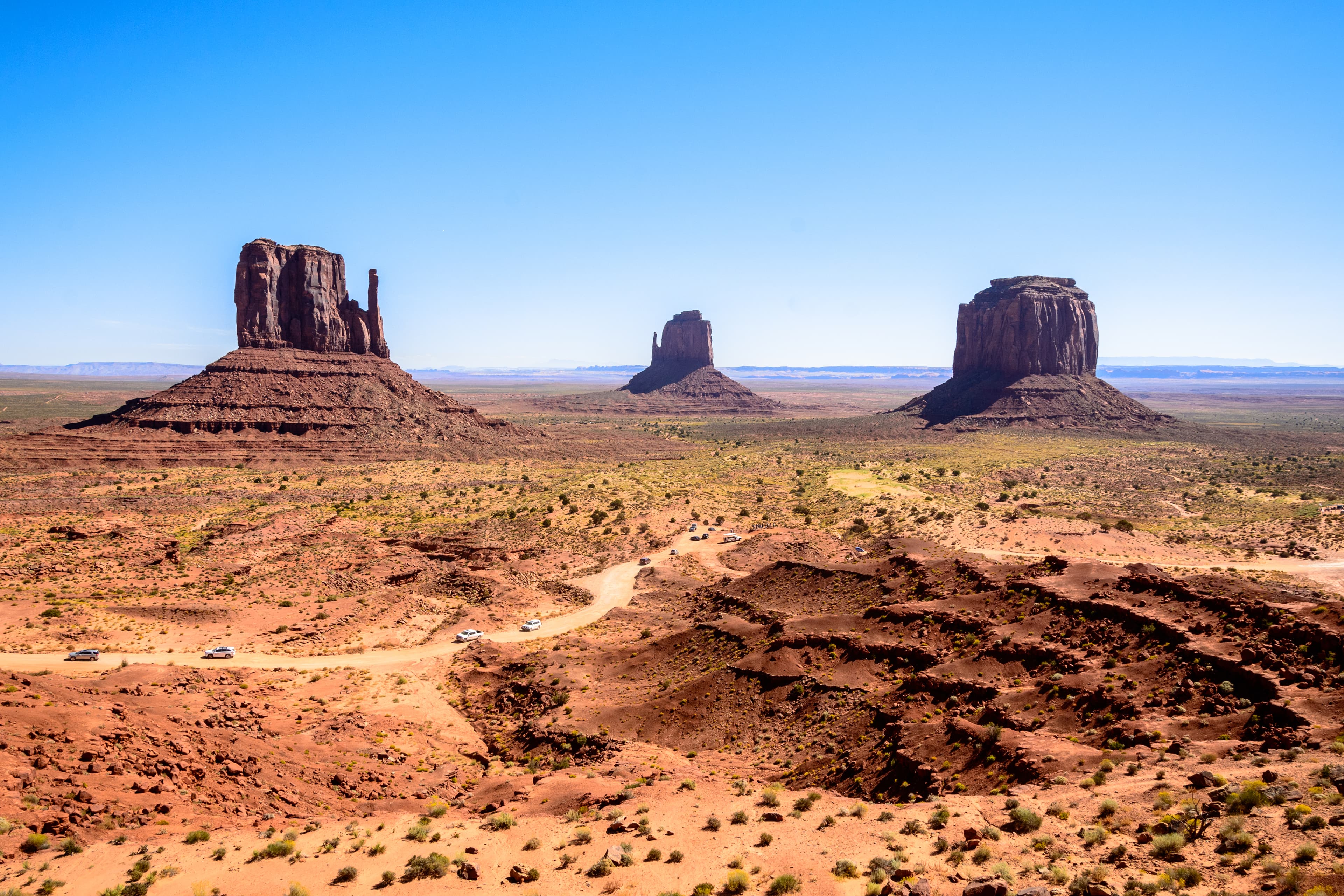
you want Grand Canyon vistas, Sedona red rocks, Antelope Canyon light shafts, and the great American road trip through red-rock country
Choose Yosemite National Park if...
you want granite cliffs, waterfalls, giant sequoias, and Tunnel View — plus a real public-transit option via YARTS from San Francisco
American Southwest
Yosemite National Park