
Yosemite National Park
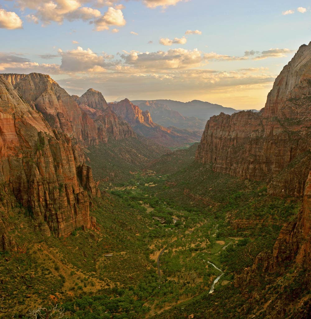
Yosemite Valley is seven miles of polished granite — El Capitan's 3,000-foot wall, Half Dome's hood above it, and three of the tallest waterfalls in North America — all visible from Tunnel View in one shot. Most visitors never leave the Valley; the high country at Tuolumne Meadows and the Mariposa Grove of giant sequoias reward the detour, and a Merced Amtrak + YARTS bus is a real budget route from San Francisco.
Tours & Experiences
Browse bookable tours, activities, and day trips in Yosemite National Park
📍 Points of Interest
Loading map...
At a Glance
- Pop.
- No permanent residents; ~4M visitors/year
- Timezone
- Los Angeles
- Dial
- +1
- Emergency
- 911
Yosemite was established on October 1, 1890 as the third US national park — and the Yosemite Grant of 1864 (signed by Lincoln) protected Yosemite Valley and the Mariposa Grove decades earlier, making this effectively the birthplace of the national park idea
The park covers roughly 750,000 acres of the central California Sierra Nevada, yet 95% of the park's ~4 million annual visitors concentrate in the 7-mile-long Yosemite Valley — a single glacier-carved gash on the floor of the park
El Capitan rises 3,000 vertical feet of solid granite from the valley floor — the world's most famous big wall and the rock climbed free-solo by Alex Honnold in the 2017 film that won an Academy Award
Yosemite Falls drops 2,425 feet in three tiers — the tallest waterfall in North America — and is fed entirely by snowmelt, which means it typically runs dry from late August through October
Half Dome's cable route (14-16 miles round trip with 4,800 feet of elevation gain) requires a permit won through an NPS lottery — the cables only go up from the Friday before Memorial Day through Columbus Day weekend
The Mariposa Grove in the park's south holds around 500 mature giant sequoias including the 3,000-year-old Grizzly Giant — some of the largest living things on Earth by volume
Top Sights
Tunnel View
📌The most photographed view in the park, and for good reason — a single pullout just past the Wawona Tunnel on Highway 41 takes in El Capitan on the left, Bridalveil Fall on the right, and Half Dome rising at the back of the valley. Ansel Adams' "Clearing Winter Storm" was shot from here. Sunrise and sunset both work, but sunset lights El Capitan in pink alpenglow. Arrive 30+ minutes early in peak season to get a parking spot.
El Capitan Meadow
📌A flat meadow on Northside Drive directly across from the 3,000-foot granite face of El Capitan. Bring binoculars and scan the wall — you will almost always spot climbers as colored dots working multi-day routes like The Nose, Salathé Wall, and Freerider. Rangers often set up scopes in the afternoon and narrate what you're watching. Don't miss the bat-like portaledges where climbers sleep on vertical ledges.
Half Dome
📌The iconic 8,842-foot dome above the valley. The full cable route is 14-16 miles round trip with 4,800 feet of gain, requires a permit via the NPS lottery (applications in March, daily lotteries in season), and the steel cables only go up roughly late May through mid-October. In storms or rain the wet granite on the cables has killed hikers — if clouds build, turn around. Shorter alternatives are Vernal Fall (2.4 mi RT) and Nevada Fall (5.4 mi RT) on the same Mist Trail.
Yosemite Falls
📌At 2,425 feet across three cascades — Upper (1,430 ft), Middle (675 ft), and Lower (320 ft) — Yosemite Falls is the tallest waterfall in North America. The paved Lower Yosemite Fall trail (1 mi loop) gets you to the base; the strenuous Upper Yosemite Fall trail (7.2 mi RT, 2,700 ft gain) climbs to the top. The falls are spectacular April-June and typically run dry from late August through October — check flow reports before hiking specifically for the waterfall.
Bridalveil Fall
📌A 620-foot ribbon waterfall that swings in the wind at the valley's west entrance — Ahwahneechee legend names it Pohono, the spirit of the puffing wind. Unlike Yosemite Falls, Bridalveil runs year-round because it drains a larger watershed. A 0.5-mile paved round-trip walk leads to the base viewing area; expect to get misted. The parking lot fills by mid-morning in summer.
Glacier Point
📌A 7,214-foot overlook 3,200 feet directly above Curry Village with one of the great views on the planet: Half Dome at eye level, Vernal and Nevada falls in the middle distance, and the High Sierra beyond. Roughly an hour's drive from the valley on Glacier Point Road (open late May through October, closed in winter). Sunset is unbeatable; bring a headlamp for the walk back to your car in the dark.
Mariposa Grove of Giant Sequoias
🌿The park's largest sequoia grove, roughly 500 mature trees including the 3,000-year-old Grizzly Giant and the California Tunnel Tree. A 2-mile Grizzly Giant loop covers the marquee trees; the full 7-mile Guardians Loop visits the upper grove. Private cars park at the Welcome Plaza near the South Entrance and ride a free shuttle up to the grove from late March through November — the grove itself is closed to private vehicles.
Mist Trail (Vernal & Nevada Falls)
📌Probably the most rewarding day hike in the valley — 317-foot Vernal Fall at 2.4 miles round trip from Happy Isles, and continuing up granite stairs to 594-foot Nevada Fall at 5.4 miles round trip. You will get genuinely soaked on the Mist Trail section in spring (pack dry layers). Emerald Pool above Vernal Fall looks inviting but has killed multiple swimmers in fast current — posted signs say DO NOT ENTER THE WATER and mean it.
Off the Beaten Path
Hetch Hetchy Reservoir
A glacier-carved valley in the park's northwest that John Muir called "a grand landscape garden, one of Nature's rarest and most precious mountain temples" — and which San Francisco dammed in 1923 over Muir's final and most bitter fight. Today it's a blue reservoir ringed by granite walls that look strikingly like Yosemite Valley's. A paved road dead-ends at O'Shaughnessy Dam; a flat 5-mile round-trip hike along the reservoir reaches Wapama Falls (at peak flow in spring, often the best waterfall experience in the park).
Hetch Hetchy receives under 5% of the park's visitors despite being a short drive off Highway 120 from the Big Oak Flat Entrance. It's the only area of the park that feels genuinely quiet in peak summer. The dam controversy is also one of the foundational stories of American conservation — a visit is a pilgrimage for anyone interested in the history of the Sierra Club.
Taft Point & The Fissures
A 2.2-mile round-trip walk from the Glacier Point Road (trailhead at Sentinel Dome parking) to a cliff edge 3,500 feet above the valley floor. What makes Taft Point unique is The Fissures — narrow vertical cracks in the granite that plunge straight down, which you can peer into with a racing heart. The cliff has no railings at the viewpoint itself (one small railing at a designated overlook). Sunset here is transcendent but get back to your car before full dark — it's a real trail, not a boardwalk.
Almost everyone driving Glacier Point Road stops only at Glacier Point itself — yet Taft Point has an even more dramatic cliff-edge experience with a fraction of the crowd. The photogenic cracked-granite lip is a favorite of photographers at golden hour. Pair it with Sentinel Dome from the same trailhead for a classic half-day loop.
Sentinel Dome
A 2.2-mile round-trip hike from the same Glacier Point Road trailhead as Taft Point, climbing to the bald granite summit of Sentinel Dome at 8,122 feet. The 360-degree view rivals Half Dome itself and requires no cables or permits — El Capitan straight across, Half Dome to the east, the Clark Range to the south, and the pale Sierra crest to the east. The iconic lone Jeffrey Pine on the summit blew down in 2003 but its weathered remains still anchor the view.
You get a Half-Dome-level panorama for the effort of a flat-to-moderate 2-mile hike with no permits or waitlists. Combined with Taft Point from the same parking lot, this is the single highest-reward half day in the park for first-time visitors who are not hiking Half Dome.
Tuolumne Grove
A smaller giant sequoia grove (roughly 25 mature trees) on the Tioga Road, reached by a 2.5-mile round-trip hike that loses and then regains 400 feet of elevation. The Dead Giant tunnel tree (still standing but long dead) is the marquee feature. Tuolumne Grove is far quieter than Mariposa Grove and much closer to Yosemite Valley, though Tioga Road access closes each winter (roughly mid-November to late May).
For visitors who cannot make the hour-plus drive to Mariposa Grove, Tuolumne Grove offers a real sequoia experience within 30 minutes of the valley — and with a fraction of the people. The return climb back out is nontrivial at 6,200 feet elevation; take water.
Mono Lake & Bodie Ghost Town (via Tioga Pass)
An entire world on the park's eastern side, accessible only when Tioga Pass (9,943 ft) is open — typically late May or June through October. Mono Lake, a 760,000-year-old alkaline lake 13 miles from the park's east entrance, is ringed by surreal tufa towers. Forty miles north, Bodie State Historic Park preserves a gold-rush ghost town frozen in "arrested decay" — one of the most authentic 19th-century towns anywhere in the US.
Most Yosemite visitors never cross Tioga Pass, which means they miss the Eastern Sierra — a fundamentally different landscape of high desert, volcanic geology, and ghost towns. Combined with Tuolumne Meadows (8,600 ft, alpine), this makes a long day that shows you more of the real Sierra Nevada than the valley ever can.
Insider Tips
Climate & Best Time to Go
Monthly climate & crowd levels
Yosemite has a Mediterranean-to-alpine climate that is dominated by elevation. Yosemite Valley sits at roughly 4,000 feet — warm dry summers, cool wet winters with occasional snow. The high country around Tuolumne Meadows (8,600 ft) and Tioga Pass (9,943 ft) runs roughly 10°C / 18°F cooler than the valley on any given day and stays under deep snow from November through May. This elevation split means you can be in shorts in the valley and a parka two hours later. Summers in the valley are classic California — blue skies, afternoon temperatures in the high 20s Celsius, cool nights, and very little rain. Thunderstorms build in the high country most afternoons, especially in July and August, and can hit Half Dome's exposed granite cables without warning. Spring is the waterfall peak — May is the single best month for Yosemite Falls — and fall brings crisp days, turning aspens in Tuolumne Meadows, and the occasional smoky day from California wildfires farther west. Winter is spectacular in the valley but demands planning: tire chains are frequently required on park roads (posted as R1/R2/R3 restrictions), Tioga Road and Glacier Point Road close completely, and Badger Pass ski area operates mid-December through March. The valley itself rarely drops deep below freezing at night and often sees dustings of snow rather than heavy accumulation. Photographers covet the stretch from late December through February for frozen waterfalls and snow-rimmed granite.
Spring
March - May36-72°F
2-22°C
Waterfall season peaks as the Sierra snowpack melts into the rivers. May is the single best month for seeing every waterfall at full flow (Yosemite Falls, Bridalveil, Vernal, Nevada). High country still snowbound — Glacier Point Road usually opens late May, Tioga Road late May to early July depending on snow year. The Merced River runs high and cold; Mist Trail soaks hikers.
Summer
June - August50-90°F
10-32°C
Hot, dry valley days and cool nights — the park's maximum visitor season. All roads including Tioga and Glacier Point open by early-to-mid July in normal snow years. Afternoon thunderstorms hit the high country most afternoons, especially July-August — lightning on Half Dome cables is a real hazard. Yosemite Falls usually dries up by mid-August. Crowd and traffic management is the single biggest challenge.
Autumn
September - early November36-77°F
2-25°C
Arguably the best balance in the park — warm dry days, cool nights, peak aspens in Tuolumne Meadows late September, and 40-60% fewer crowds than August. Tioga Road usually stays open through mid-October; Glacier Point Road through late October. The one serious downside is wildfire smoke, which can roll in from Northern California fires and occasionally close the valley for days.
Winter
November - February23-54°F
-5 to 12°C
Tioga Road and Glacier Point Road close (typically November through May or June). Valley roads stay open but chain requirements are frequent — carry chains between November 1 and April 30 regardless of weather. Badger Pass ski area operates mid-December through March. Horsetail Fall's "firefall" glow peaks in mid-to-late February around sunset, drawing large crowds that now require reservations. Bridalveil flows year-round; Yosemite Falls returns by late November with the first big storm.
Best Time to Visit
May is the single best month for waterfalls — Yosemite Falls, Bridalveil, Vernal, and Nevada all run at full snowmelt peak. September offers the best warm-weather trip for most visitors: warm dry days, fewer crowds than summer, Tioga Road still open for the high country, and elk rut and aspens starting. October brings turning aspens in Tuolumne Meadows plus Tioga Road usually still accessible through mid-month. July and August maximize accessibility but deliver the worst crowds of the year — entry reservations required, parking lots full by 9am, and lodge bookings needed a year ahead. February brings the short but dramatic Horsetail Fall "firefall" window which has become its own mini-season with its own reservation system.
Spring (March - May)
Crowds: Moderate; lower in March-April, climbing by Memorial DayWaterfall peak season. Snowmelt from the Sierra pours into the Merced River and every valley waterfall runs at maximum flow. May is the single best month for Yosemite Falls and Bridalveil. Tioga Road and Glacier Point Road remain closed; you're confined to Yosemite Valley and the Mariposa Grove / Wawona area (plus Hetch Hetchy year-round). Weather swings from snow in March to warm sunny days in late May.
Pros
- + Waterfalls at peak flow (especially Yosemite Falls)
- + Dogwood blooms in the valley late April-May
- + Lower lodge rates before Memorial Day
- + Fewer crowds than summer
Cons
- − High country (Tioga Road, Glacier Point Road) still closed
- − Cold wet weather possible through April
- − Mist Trail soaks hikers and can close temporarily
- − Chain requirements on valley roads through April
Summer (June - August)
Crowds: Extremely high — the most crowded period of the yearPeak season with all roads including Tioga Pass and Glacier Point typically open by early July in normal snow years. Entry reservations are required during peak periods; lodge rooms booked 12+ months in advance. Temperatures are warm (27-32°C in the valley) with cool nights and frequent high-country afternoon thunderstorms. Yosemite Falls usually dries up by mid-August.
Pros
- + All roads and facilities open — Tioga, Glacier Point, Mariposa Grove shuttle
- + Warm dry weather reliable for hiking
- + Longest days (14+ hours of daylight)
- + Half Dome cables season (late May-October)
Cons
- − Extreme crowds and entry reservations required
- − Parking lots full by 9am at popular sites
- − Lodge rooms booked a year ahead
- − Yosemite Falls often dry by August
- − Wildfire smoke risk increasing through August
Autumn (September - October)
Crowds: Moderate in early September, low by OctoberThe best balance of weather and crowds for many visitors. Warm dry days, cool nights, 40-60% fewer people than August, and Tioga Road + Glacier Point Road typically open through mid-October. Aspens in Tuolumne Meadows turn gold in late September. Wildfire smoke from Northern California is the main wildcard — occasionally the valley closes for a few days when air quality collapses.
Pros
- + Warm dry days, cool nights
- + Golden aspens in Tuolumne Meadows late September
- + Dramatically lower crowds than summer
- + Tioga Road usually open through mid-October
- + Lower lodge rates
Cons
- − Wildfire smoke risk from Northern California fires
- − Early October can see first high-country snow
- − Some facilities close starting in mid-October
- − Yosemite Falls still dry until late November
Winter (November - February)
Crowds: Low overall; high concentrated spikes around firefall weekTioga Road and Glacier Point Road close for the season (typically November to late May or June). Valley roads stay open but tire chain requirements are frequent and visitors must carry chains November 1-April 30. The valley with snow is genuinely magical — far fewer people than summer, the Ahwahnee at its grand-hotel best, and Badger Pass ski area operating mid-December through March. Horsetail Fall's "firefall" glow peaks around sunset in mid-to-late February, drawing unusually large crowds for winter and requiring reservations on peak evenings.
Pros
- + Valley in snow is spectacular and photogenic
- + Badger Pass skiing and cross-country at Crane Flat
- + Lower lodge rates (except firefall week)
- + Frozen waterfalls and icicles at Bridalveil
- + Ahwahnee Bracebridge Dinner (December)
Cons
- − Tioga and Glacier Point Roads closed
- − Chains required frequently on valley roads
- − Limited daylight (10 hours)
- − Many trails and upper lodges closed for season
- − Firefall week parking chaos
🎉 Festivals & Events
Horsetail Fall "Firefall"
Mid-to-late FebruaryA brief 10-day window around sunset in February when the setting sun backlights Horsetail Fall on El Capitan in a molten-lava orange glow. The park implements entry reservations and traffic controls for peak evenings. Photographers arrive hours early for parking along Northside Drive.
Bracebridge Dinner at the Ahwahnee
DecemberA lavish multi-course, multi-act period dinner at the Ahwahnee Hotel, staged since 1927. Based on a scene from Washington Irving's "Sketch Book." Seats sell out roughly a year in advance despite hefty prices.
Vintners' Holidays
November - early DecemberA series of California winemaker weekends at the Ahwahnee Hotel featuring tastings, seminars, and multi-course wine dinners. A quieter pre-Christmas tradition in the valley.
Chefs' Holidays
January - FebruaryCompanion series to Vintners' Holidays, with guest chef appearances and multi-course themed dinners at the Ahwahnee. A smart reason to visit the valley in the depths of winter.
Junior Ranger Programs & Ranger Walks
Year-round (peak summer)Free ranger-led walks, evening programs at campground amphitheaters, and Junior Ranger activity booklets for kids. Not a festival but a backbone of the Yosemite experience.
Safety Breakdown
Very Safe
out of 100
Yosemite is safe from a crime perspective — property crime in parking lots is the main concern. The real hazards are natural: fatal falls on Half Dome and other high-exposure granite, drownings in the Merced River (especially Emerald Pool above Vernal Fall), rockfall, black bears raiding cars and campsites, lightning at altitude, and wildfire smoke. Yosemite averages 12-15 fatalities per year — the highest of any US national park by total count — primarily from falls and drownings. The Merced River kills multiple visitors every year. Emerald Pool above Vernal Fall looks like a swimming hole but is fed by the slick granite above Nevada Fall, and people regularly slip in and get swept over the 317-foot drop. Signs posted along the river reading "IF YOU GO OVER THE FALLS YOU WILL DIE" are not hyperbole. Half Dome's cables have killed hikers caught in thunderstorms — wet granite plus lightning is not survivable on that slope. The 2017 Royal Arches rockfall killed a climber and reminded everyone that the valley's granite walls still drop rock without warning. Black bears in the valley are highly habituated; food in a car overnight will almost certainly be broken into unless it's in a bear locker.
Things to Know
- •Never swim in the Merced River above Vernal Fall — Emerald Pool has killed multiple people who slipped on slick granite and were swept over the 317-foot drop. The posted warning signs are accurate.
- •Do not attempt Half Dome's cables in thunderstorms, rain, or wet conditions — wet granite on 45-degree slopes has no friction. If clouds build in the afternoon, turn around; the mountain will be there next year.
- •Store all food, coolers, scented toiletries, and trash in bear lockers at campsites and trailheads — never leave them in your car overnight. Bears break into 200+ cars a year in the park.
- •Stay well back from cliff edges at Taft Point, Glacier Point, and every waterfall overlook. Multiple fatalities each year involve selfies taken too close to unprotected drops.
- •Carry more water than you think you need in summer — the valley runs hot and dry, and 6-10L days are routine for Half Dome. Water refill stations exist in the valley but not on most trails.
- •Be alert for rockfall, especially after rain or in spring thaw — the 2017 Royal Arches fatality reminded everyone that the valley's granite walls still shed debris. Heed any posted rockfall warnings immediately.
- •Rattlesnakes live in the valley and at lower elevations — watch where you step, especially on sun-warmed rocks and trail edges in summer.
- •Check wildfire conditions and air quality at nps.gov/yose before and during any summer-fall visit — Northern California smoke can close the valley on short notice.
Natural Hazards
Emergency Numbers
General Emergency
911
Yosemite Park Dispatch (24/7)
209-379-1992
Yosemite Medical Clinic (valley, year-round)
209-372-4637
Search and Rescue / Preventive Search and Rescue
209-379-1992 (via park dispatch)
Road & Weather Information (automated)
209-372-0200
Costs & Currency
Where the money goes
USD per dayQuick cost estimate
Customize per category →Estimates based on regional averages. Flight prices vary by season and airline.
budget
$80-140
Camping ($36-60) or hostel in gateway town, groceries prepped pre-park, YARTS bus instead of car, free ranger programs
mid-range
$280-500
Yosemite Valley Lodge or Curry Village heated cabin, lodge restaurant dinners, guided day activity, rental car
luxury
$800+
Ahwahnee Hotel room or suite, fine dining at the Ahwahnee, private guided climbing or photography tour, scenic flight
Typical Costs
| Item | Local | USD |
|---|---|---|
| Park EntryPrivate vehicle, 7-day pass | USD 35 | $35 |
| Park EntryAmerica the Beautiful annual pass (all NPS sites) | USD 80 | $80 |
| Park EntryPeak-season entry reservation (when required) | USD 2 booking fee | $2 booking fee |
| AccommodationNPS campground (Upper Pines, North Pines, Lower Pines) | USD 36-60 | $36-60 |
| AccommodationHousekeeping Camp (valley, shared bath) | USD 130 | $130 |
| AccommodationCurry Village tent cabin (canvas, heated) | USD 150-200 | $150-200 |
| AccommodationYosemite Valley Lodge room | USD 250-400 | $250-400 |
| AccommodationThe Ahwahnee (historic grand hotel) room or suite | USD 400-700+ | $400-700+ |
| AccommodationGateway town mid-range hotel (Mariposa, Oakhurst, El Portal) | USD 140-260 | $140-260 |
| FoodCafeteria / counter lunch (Degnan's, Village Grill) | USD 12-20 | $12-20 |
| FoodSit-down dinner at lodge dining room | USD 30-60 | $30-60 |
| FoodAhwahnee Dining Room dinner entree | USD 40-70 | $40-70 |
| TransportYARTS bus from Merced (includes park entry) | USD 30 one-way | $30 |
| TransportYARTS bus from nearer gateway (Mariposa, Groveland) | USD 10-20 one-way | $10-20 |
| TransportCar rental per day (SFO/OAK) | USD 50-140 | $50-140 |
| ActivitiesGlacier Point tour shuttle | USD 30-50 | $30-50 |
| ActivitiesHalf Dome permit (won via lottery) | USD 10 lottery fee + $10 permit | $20 |
| GearBear canister rental (Curry Village Mountain Shop) | USD 5/trip + deposit | $5+ |
💡 Money-Saving Tips
- •Buy the America the Beautiful annual pass ($80) if you'll visit any other NPS site within 12 months — it pays for itself in 3 park entries
- •Camp inside the park at Upper/Lower/North Pines ($36-60/night) — the cheapest way to stay inside the park, and puts you at valley trailheads at dawn before crowds
- •Take the Amtrak + YARTS route from San Francisco — roughly $60-90 each way and includes your park entry; avoids rental car, parking hassles, and entry reservations
- •Stay in a gateway town (Mariposa, Oakhurst, Groveland, El Portal) and commute in — hotel rates are 30-50% cheaper than in-park lodges
- •Book Yosemite Valley Lodge or the Ahwahnee 12-13 months in advance — the day the reservation window opens — for any chance at peak-summer dates
- •Buy groceries in Mariposa or Oakhurst before entering — in-park village stores are 30-50% more expensive than supermarket prices
- •Ranger-led walks and evening campground programs are free — one of the best values in the park for first-time visitors
- •Off-peak visits in late April or late September can save 30-40% on lodge rates with better waterfalls (spring) or fewer crowds (fall)
US Dollar
Code: USD
US dollars only — international visitors should exchange currency or use ATMs at SFO, OAK, SJC, or FAT airports on arrival. ATMs are available in Yosemite Valley at Yosemite Village and Curry Village, and in gateway towns (Mariposa, El Portal, Oakhurst, Groveland). Cell and card networks are unreliable in the park interior, so carry some cash for tips, YARTS bus fares, and small purchases. Gateway towns all have normal US banking infrastructure.
Payment Methods
Credit and debit cards are accepted at all in-park lodges, restaurants, stores, and entry stations. Contactless and Apple/Google Pay work at most points of sale but require cell signal, which is spotty throughout the park. Cash is useful for small tips, YARTS bus fares, some self-service registration boxes at campgrounds, and small gateway-town businesses. Park entry stations accept card even when cell service is down.
Tipping Guide
18-22% is standard for table service; 20% is the reliable default. Lodge restaurants (the Ahwahnee Dining Room, Mountain Room at Yosemite Valley Lodge, Wawona Hotel Dining Room) follow normal US full-service tipping. Counter-service at Degnan's Kitchen or the Village Grill does not require tipping but tip jars are appreciated.
$1-2 per drink for beer/wine or simple orders; 18-20% for cocktails or full bar service. The Ahwahnee Bar and the Mountain Room Lounge follow normal US tipping.
Glacier Point tour drivers: $5-15 per person for a round-trip shuttle. YARTS bus drivers: optional $2-5 but not expected. Private climbing guides and hiking guides: 15-20% of the trip cost. NPS rangers are federal employees and cannot accept tips.
$2-5 per bag for bellhops at the Ahwahnee and Yosemite Valley Lodge. $3-5 per night for housekeeping in lodge rooms. Valet at the Ahwahnee: $3-5 per car.
$5-10 per person one-way for airport shuttles from Fresno or Merced to gateway towns. Not strictly required but standard practice in the US.
How to Get There
✈️ Airports
Fresno Yosemite International Airport(FAT)
95 mi (153 km) to South Entrance / 2.5 hr to valleyThe closest airport to Yosemite by driving time, with direct flights from most major US hubs. Rental car inventory is decent but smaller than SFO; book ahead in summer. A good option if you're flying specifically for Yosemite and skipping the Bay Area.
✈️ Search flights to FATSan Francisco International Airport(SFO)
195 mi (314 km) / 4 hr by carThe most common arrival airport for international visitors — every major international airline serves SFO. Combine with 1-2 days in San Francisco on either end of the trip. Rental cars are plentiful and competitively priced. The Amtrak + YARTS option from Emeryville (across the bay) is the budget non-car route.
✈️ Search flights to SFOOakland International Airport(OAK)
200 mi (322 km) / 4 hr by carThe Bay Area's budget-focused airport with strong Southwest Airlines service. Rental cars often cheaper than SFO. Slightly shorter drive to the park than SFO if you're heading directly to Yosemite. Well-connected to Amtrak via BART to Emeryville.
✈️ Search flights to OAKSan Jose International Airport(SJC)
180 mi (290 km) / 3.5 hr by carA smaller Bay Area airport with fewer international flights but shorter lines and shorter drives to Yosemite than SFO or OAK. Good option if you're combining the park with Silicon Valley or coastal California.
✈️ Search flights to SJC🚆 Rail Stations
Merced Amtrak Station
80 mi (129 km) from valley via YARTSThe closest Amtrak station to Yosemite and the key link in the classic public-transit route from San Francisco. The San Joaquin train runs several times daily between Emeryville (connected by bus to SF) and Merced; the trip takes about 3 hours. At Merced, YARTS buses connect directly to Yosemite Valley — 2.5 hours of additional travel. Total SF-to-Yosemite budget route is roughly 6-7 hours and USD 60-90 each way, and the bus ticket includes your park entry.
Emeryville Amtrak Station (Bay Area connection)
The effective "San Francisco" Amtrak station — Amtrak runs a free shuttle bus from downtown SF and other Bay Area points to Emeryville to connect with trains heading east. Begin an Amtrak + YARTS Yosemite trip here. Also the starting point for the California Zephyr if combining Yosemite with a cross-country rail trip.
🚌 Bus Terminals
Arch Rock Entrance (Highway 140 West, year-round)
The primary year-round entrance, on Highway 140 from Merced/Mariposa/El Portal. Stays open in winter because it follows the Merced River at a lower elevation than the other entrances. YARTS buses from Merced and Mariposa use this entrance. Passes the historic El Portal gateway village before entering the park.
Big Oak Flat Entrance (Highway 120 West, year-round)
The northwest entrance on Highway 120 from Groveland and Sonora. Year-round but chains frequently required in winter. Connects to Tioga Road (seasonal) and Hetch Hetchy Road (year-round) before descending into Yosemite Valley. YARTS buses from Sonora/Groveland use this entrance seasonally.
South Entrance (Highway 41, year-round)
The southern entrance on Highway 41 from Oakhurst and Fresno. Puts you closest to the Mariposa Grove of giant sequoias and Wawona. Year-round but chains may be required in winter. Typically the entrance used by visitors flying into Fresno (FAT) and the shortest drive time from Los Angeles.
Tioga Pass Entrance (Highway 120 East, SEASONAL)
The east entrance at 9,943 feet on Highway 120, connecting from Lee Vining, Mono Lake, and Mammoth Lakes. Closed approximately November through late May or June depending on snowpack — often one of the last high passes in the lower 48 to reopen each year. Seasonal YARTS buses from Mammoth Lakes use this entrance in summer and fall.
Getting Around
Yosemite is one of the very few US national parks where you can genuinely arrive and get around without a car — a rare enough claim that it's worth emphasizing. YARTS (Yosemite Area Regional Transportation System) runs scheduled buses into the park from four gateway regions, connecting with Amtrak at Merced and functioning as real public transit rather than a tour bus. Inside Yosemite Valley, a free year-round shuttle loops every 10-20 minutes between the 21 major stops — lodges, trailheads, villages, and campgrounds — and in peak summer the valley is essentially a pedestrian-and-shuttle zone rather than a drive-through. For visitors coming from San Francisco, the budget route is genuinely competitive: take Amtrak from Emeryville (connected to SF by bus) to Merced (3 hours), then YARTS into the valley (2.5 hours). Total cost is often USD 60-90 each way and avoids the parking nightmare and summer entry reservation system that plague car arrivals. For visitors who want to see the whole park (Glacier Point, Mariposa Grove, Tioga Road, Hetch Hetchy), a car becomes much more useful — YARTS only covers the main park corridors and doesn't serve the Glacier Point Road or Tioga Road high country. Inside the valley, the free shuttle is genuinely essential in summer — the parking lots at trailheads fill by 8-9am and the shuttle lets you hop between, say, Happy Isles (for Mist Trail) and Yosemite Falls without moving your car. A seasonal Glacier Point shuttle runs from the valley in summer for those without cars. There is no Uber or Lyft coverage inside the park. Cell service is spotty in the valley and absent in most of the park.
YARTS (Yosemite Area Regional Transportation System)
USD 10-30 one-way from gateway towns; USD 30 from Merced (includes park entry)Scheduled public bus service into the park from four corridors: Merced (Highway 140, year-round, connects to Amtrak), Mariposa (Highway 140), Sonora/Groveland (Highway 120 West, summer-fall), and Mammoth Lakes/Lee Vining (Highway 120 East via Tioga Pass, summer only). Buses drop at major valley stops. Your paid park entry is included in the YARTS ticket, meaning you skip the entry reservation requirement during peak periods.
Best for: Budget travelers, those coming from SF via Amtrak, anyone skipping the entry reservation hassle
Yosemite Valley Free Shuttle
FreeA hop-on-hop-off free loop serving 21 stops around the valley floor: lodges, Yosemite Village, Curry Village, campgrounds, and major trailheads including Happy Isles (Mist Trail), Yosemite Falls, and Camp 4. Runs 7am-10pm in summer every 10-20 minutes; reduced winter schedule. Essential in peak season when trailhead parking is impossible.
Best for: Getting between valley lodges, trailheads, and restaurants without moving your car
Glacier Point Tour (Seasonal)
USD 30-50 round trip; USD 25 one-way hikerA concessionaire-operated bus from the valley to Glacier Point and back, running roughly late May through October while Glacier Point Road is open. Runs several times daily; reservations recommended in peak season. Useful for visitors without cars or those wanting one-way hiker drop-off for Four Mile Trail or Panorama Trail descent routes.
Best for: Visitors without cars, one-way hiker shuttles for Four Mile or Panorama Trails
Car Rental
USD 50-140/day at major Bay Area and Central Valley airportsThe most flexible option, especially for visitors planning to see Glacier Point, Mariposa Grove, Tioga Road/Tuolumne Meadows, or Hetch Hetchy. Pick up at SFO, OAK, SJC, or Fresno (FAT). In peak periods (roughly late May to late September, plus February firefall) private vehicles must have a paid entry reservation in addition to the park fee — check nps.gov/yose for current rules.
Best for: Full-park exploration, reaching Glacier Point/Tioga/Hetch Hetchy, flexibility for dawn/dusk starts
Bicycle
USD 13-45/day rental (hourly to full day)The Valley has roughly 12 miles of paved bike paths connecting lodges, villages, and trailheads — the best way to move around the valley floor without waiting for shuttles. Rentals at Yosemite Valley Lodge and Curry Village. Not allowed on hiking trails or park roads outside the bike path system. A serious option in April-October; most paths close for snow in winter.
Best for: Valley floor exploration, reaching Mirror Lake, avoiding the shuttle wait
🚶 Walkability
Yosemite Valley itself is walkable and shuttle-friendly — lodges, restaurants, visitor center, and major trailheads are all within a 2-mile radius connected by paved paths and the free shuttle. Outside the valley, distances and terrain make walking between sights impractical; Mariposa Grove is a 1-hour drive south and Tuolumne Meadows is a 1.5-hour drive east. There is no rideshare (Uber/Lyft) coverage inside the park.
Travel Connections

San Francisco
The most common pre- or post-park stop — a couple of days in the city on either end of a Yosemite trip is the classic California itinerary. SFO is a major international hub, and the Amtrak-to-Merced-to-YARTS bus chain from Emeryville (across the bay) is one of the few real public transit routes to a US national park. Allow at least two full days for the city.

Los Angeles
A reasonable southern bookend, especially if combining Yosemite with Joshua Tree or the coast. The drive through the Central Valley on CA-99 is flat and not scenic; most visitors break the trip at Bakersfield or skip directly to a one-way flight home from Fresno (FAT). LAX offers many more international connections than SFO for some regions.

Lake Tahoe
The most scenic road link between Yosemite and Tahoe is Tioga Road (CA-120) east out of the park, up to Mono Lake, and north through the Eastern Sierra — but this route is closed roughly November through May or June when Tioga Pass is snowed in. In winter you'll loop north via Stockton and I-80. Tahoe pairs especially well with a late-summer Yosemite trip.

Sequoia & Kings Canyon National Parks
The best thematic pairing with Yosemite — the neighboring Sierra parks contain the largest giant sequoias on Earth (General Sherman) and the deepest canyon in the US (Kings Canyon). Much less crowded than Yosemite and a natural extension if you loved the Mariposa Grove. No direct park-to-park road; you drop to the San Joaquin Valley and drive around.
Zion National Park
A long road-trip extension but an outstanding pairing — Zion offers radically different sandstone geology from Yosemite's granite and extends naturally into a Utah Mighty Five tour (Bryce, Capitol Reef, Arches, Canyonlands). Most people break the drive in Las Vegas. If you can only do two national parks, Yosemite + Zion covers a huge span of American geology.

Grand Canyon National Park
Another long-but-worthwhile road-trip bookend, especially combined with Zion on a 2-week Southwest loop. Most visitors break the drive in Las Vegas or Flagstaff. The South Rim is open year-round; the North Rim closes mid-October through mid-May. Very different from Yosemite — desert canyon rather than glaciated granite — which makes the pairing work.
Entry Requirements
Yosemite is in the United States. Most international visitors need either an ESTA (Visa Waiver Program) or a full visitor visa (B-1/B-2) to enter. Travelers from visa-waiver countries should apply for ESTA at least 72 hours before travel. US citizens need only valid ID. Park entry is separate from US entry — no border or visa control at park gates, but a park entry fee applies and peak-season dates can require an entry reservation in addition to the fee.
Entry Requirements by Nationality
| Nationality | Visa Required | Max Stay | Notes |
|---|---|---|---|
| US Citizens | Visa-free | Unlimited | Valid government-issued ID required (REAL ID or passport for domestic flights after May 2025). |
| UK Citizens | Visa-free | 90 days | ESTA required under Visa Waiver Program (USD 21, apply online at esta.cbp.dhs.gov). Valid for 2 years or until passport expires. |
| EU Citizens | Visa-free | 90 days | Most EU nationals qualify for ESTA (USD 21). Apply at least 72 hours before travel. Not all EU nationalities qualify — check the official list. |
| Canadian Citizens | Visa-free | 6 months | No ESTA or visa required for tourism. Valid passport required at land and air crossings. |
| Australian Citizens | Visa-free | 90 days | ESTA required (USD 21). Apply at esta.cbp.dhs.gov. |
| Indian Citizens | Yes | As per visa | B-1/B-2 visitor visa required. Apply at US consulate; current wait times can be 6-24 months depending on consulate. Interview required. |
| Chinese Citizens | Yes | As per visa | B-1/B-2 visitor visa required. 10-year multiple-entry visas common for business/tourism. Apply through US embassy/consulate. |
Visa-Free Entry
Tips
- •Apply for ESTA only at esta.cbp.dhs.gov — many third-party sites charge 3-5x the official $21 fee for no added value
- •Check Yosemite's current peak-season entry reservation rules at nps.gov/yose before your trip — requirements change year to year and apply during summer and the February firefall window
- •YARTS bus tickets INCLUDE park entry, so arriving by bus bypasses both the entry fee and the peak-season reservation requirement — a significant hidden benefit
- •The $35/vehicle park entry fee is separate from any ESTA or visa costs and valid for 7 consecutive days
- •US Customs at your arrival airport (SFO, LAX, SJC, OAK) will ask about your accommodation and return plans — having park lodge or campground booking confirmations speeds the process
- •Cell service is unreliable throughout the park — download offline maps (NPS app, Google Maps offline) and print your lodging reservations as backup
Shopping
Shopping in Yosemite is concentrated in a few village clusters — Yosemite Village and Curry Village in the valley, the Wawona Store near the South Entrance, and the Tuolumne Meadows Store in the high country (summer only). The most distinctive in-park shopping is at the Ansel Adams Gallery in Yosemite Village, which has been selling prints in the park since 1902 and is as much a museum as a store. For groceries, camping supplies, and cheaper souvenirs, most visitors stock up in the gateway towns — Mariposa and Oakhurst have full supermarkets; El Portal has a small general store. Park-branded merchandise uses the same themes as most NPS units (T-shirts, mugs, passport stamps, Junior Ranger kits) but with a photography-heavy angle reflecting Yosemite's role in the history of landscape photography. If you want a souvenir with genuine local meaning, a signed Ansel Adams reproduction print from the gallery or a climbing guidebook from the Curry Village Mountain Shop is a more interesting take than the usual gift-shop fare. Miwok and Paiute crafts are sold at the Yosemite Museum shop, with proceeds supporting the park's Indian Cultural Exhibit. In-park prices for snacks, drinks, and gifts run roughly 20-40% above gateway-town prices; plan ahead if you're on a tight budget.
Yosemite Village
main commercial hubThe park's primary shopping area, clustered around the Valley Visitor Center. Houses the Ansel Adams Gallery, Yosemite Museum, Village Store (groceries, beer, wine, camping basics), Degnan's Kitchen cafe, and the Yosemite Conservancy bookstore. Best for natural history books, photography prints, and grabbing last-minute supplies before heading into the backcountry.
Known for: Ansel Adams prints and signed reproductions, Yosemite Conservancy field guides, NPS passport stamps, historical photographs, groceries
Curry Village Mountain Shop
outdoor / climbing shopA legit climbing and outdoor shop in Curry Village, stocked for the Camp 4 climbing culture that made the park famous. Sells Yosemite climbing guidebooks (Supertopo, Reid's "Rock Climbs of Yosemite Valley"), bear canisters, approach shoes, camping supplies, and outdoor apparel. The gear is real and the staff can actually answer climbing route questions.
Known for: Climbing guidebooks, bear canister rentals/sales, approach shoes, camping gear, climbing-themed T-shirts
Wawona Store & Pioneer Yosemite History Center
historic gateway storeA general store near the South Entrance dating to the 1870s, right next to the Pioneer Yosemite History Center with its collection of relocated historic buildings. Sells groceries, camping supplies, and gifts with a quieter, smaller-town feel than the valley shops. Convenient stop before or after visiting Mariposa Grove.
Known for: Basic groceries, historic-themed gifts, firewood and ice, Wawona Hotel souvenirs
Tuolumne Meadows Store (Seasonal)
seasonal high-country storeA small store and grill at Tuolumne Meadows (8,600 ft) open roughly late May through September. Stocks basic groceries, camping supplies, and a decent selection of high-country hiking books. The adjoining grill does burgers and breakfast with a devoted backpacker clientele finishing the John Muir Trail or Pacific Crest Trail sections.
Known for: Backpacker-friendly groceries, Tuolumne-themed gifts, PCT/JMT section hiking supplies
Mariposa Town Shops (Gateway)
gateway town main streetA 19th-century gold rush town on Highway 140 that serves as the nearest full-service town on the main western approach. Full supermarket, a handful of independent galleries and bookstores, and several classic-car and antique shops. Good stop to fill up on groceries, ice, and camp supplies before entering the park — prices are significantly lower than in-park.
Known for: Full grocery supermarket, gold rush antiques, independent galleries, camp fuel
🎁 Unique Souvenirs to Look For
- •Signed Ansel Adams reproduction prints from the Ansel Adams Gallery in Yosemite Village — sold here since 1902
- •NPS Passport and entrance-station cancellation stamps — one per entrance you pass through (Arch Rock, Big Oak Flat, South, Tioga Pass, Hetch Hetchy)
- •Yosemite climbing guidebooks ("Rock Climbs of Yosemite Valley" by Don Reid; Supertopo's El Cap and Half Dome guides) from Curry Village Mountain Shop
- •Miwok and Paiute basketry reproductions and jewelry from the Yosemite Museum shop (Indian Cultural Exhibit) — proceeds support park cultural programs
- •Giant sequoia seeds and native California wildflower seed packets from Mariposa Grove and valley gift shops
- •Yosemite honey and jam from Sierra Nevada apiaries, sold at Village Store and gateway markets in Mariposa and Oakhurst
- •Yosemite Conservancy field guides (wildflowers, birds, geology) — the park's nonprofit partner publishes the best pocket guides to the park
- •Horsetail Fall "firefall" photography prints (seasonal February event) — several gallery photographers specialize in this singular light effect
Language & Phrases
English is universal. What trips up first-time visitors is the dense climbing and NPS jargon used by rangers, signs, other hikers, and Camp 4 residents. Yosemite has its own vocabulary because of its role as the birthplace of American big-wall climbing — knowing a handful of these terms makes ranger programs, trailhead signs, and overheard conversations a lot more understandable.
| English | Translation | Pronunciation |
|---|---|---|
| The Valley | Yosemite Valley specifically — the 7-mile glacial canyon where 95% of visitors go; never refers to the rest of the park | THE VAL-ee — always capitalized in park usage |
| Big wall | A rock face so large it takes multiple days to climb — typically 1,000+ feet. El Capitan and Half Dome are the archetypes | BIG WALL — always refers to multi-day climbing, not just tall cliffs |
| El Cap | El Capitan — the 3,000-foot granite monolith on the north side of the valley | EL KAP — climbers never say the full name |
| Half Dome cables | The steel cable handholds up the final 400 vertical feet of Half Dome — in place roughly late May to mid-October; permit required; lethal in storms | HAF DOHM KAY-bulz |
| Camp 4 | The legendary walk-in climber campground at the base of Yosemite Falls — National Historic Landmark as birthplace of American big-wall climbing | CAMP FOR |
| Firefall | The mid-to-late February natural event where the setting sun lights Horsetail Fall on El Capitan in a lava-orange glow | FIRE-fall — two words in park usage |
| YARTS | Yosemite Area Regional Transportation System — the public bus that actually serves the park | yarts — one syllable, rhymes with "arts" |
| Tuolumne | The Miwok-derived name for the meadows and river on the high-country east side of the park | too-AHL-uh-mee |
| Ahwahnee | The Miwok name for Yosemite Valley; also the grand hotel, which was called The Majestic briefly and reverted in 2019 | ah-WAH-nee |
| Bear canister | A hard-sided cylinder for food storage in the backcountry — required for all overnight wilderness travel | BEAR CAN-is-tur |
| Leave No Trace | The 7 wilderness ethics principles — pack out everything including TP and food scraps | LEEV NOH TRAYS — always abbreviated "LNT" |
| Mist Trail | The Vernal/Nevada Fall trail from Happy Isles — you will get genuinely soaked in spring | MIST TRAYL |