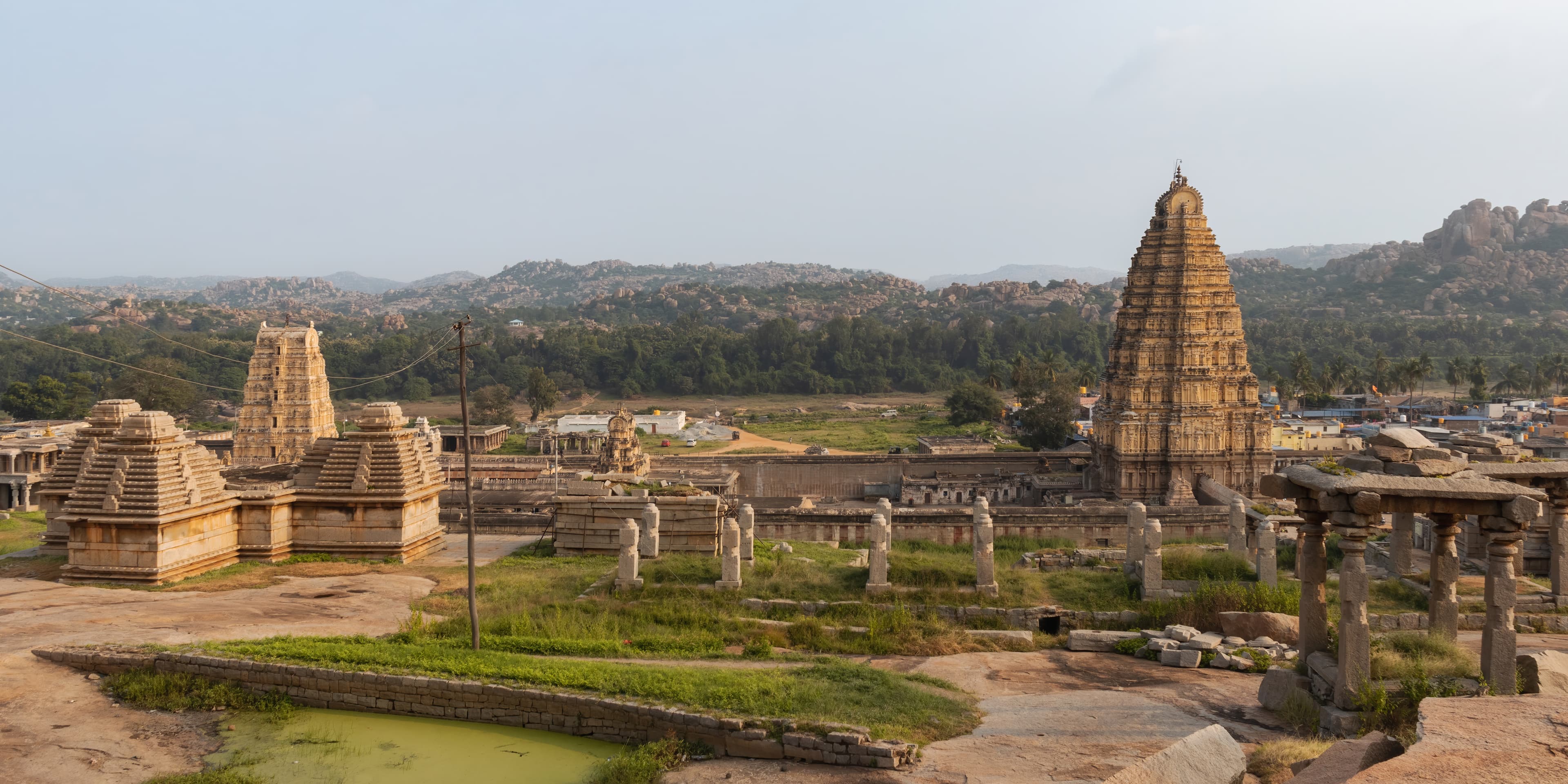
Hampi
India
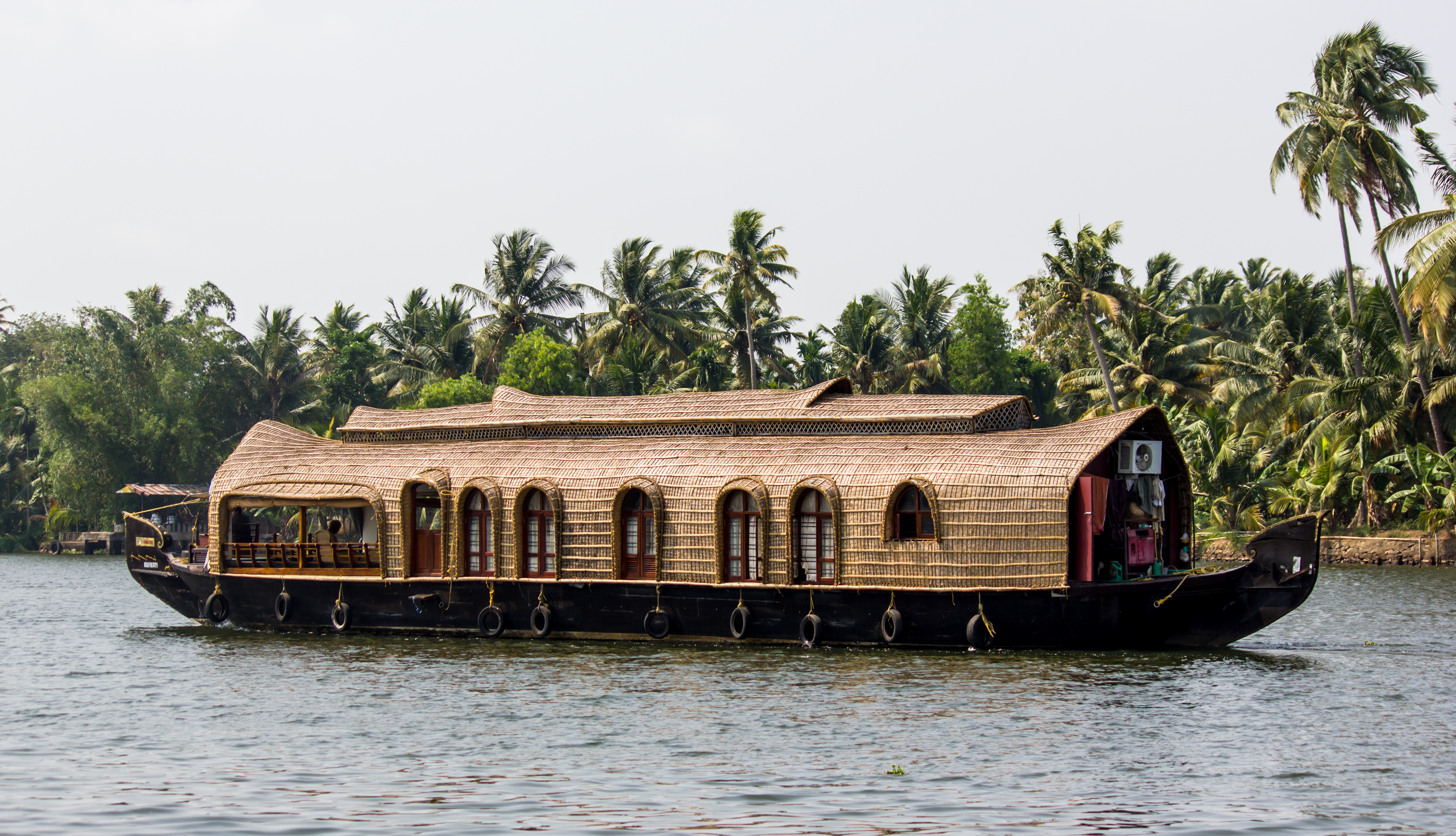
Kerala
India
Hampi
Kerala
💰 Budget
🛡️ Safety
Hampi
Hampi is a safe destination by Indian standards, with violent crime toward tourists extremely rare. The primary hazards are environmental rather than human — heat stroke in summer, slippery barefoot temple steps, and monkey bites from the large Rhesus macaque population around the temples. India's overall safety index sits around 112 on global peace indices; Hampi, as a pilgrimage and tourist town, is notably calmer than urban India.
Kerala
Kerala is consistently rated among the safest states in India for tourists, including solo female travelers. Its high literacy rate, organized tourism infrastructure, and strong local governance contribute to a lower crime rate than most Indian states. The primary hazards are environmental — monsoon flooding, coastal currents, and wildlife in forested areas — rather than personal safety concerns.
⭐ Ratings
🌤️ Weather
Hampi
Hampi sits on the Deccan Plateau in northern Karnataka, giving it a semi-arid climate with extremes in both directions. The tourist season runs mid-October to mid-March, when temperatures are pleasant and the granite ruins are comfortable to explore on foot. The remaining months — summer heat peaking above 40°C and a monsoon that turns paths muddy — make off-season visits genuinely challenging.
Kerala
Kerala has a tropical climate governed by two monsoon cycles. The southwest monsoon (June-September) is the heaviest in mainland India, bringing thunderous daily rainfall, high humidity, and a dramatic transformation of the landscape into intense green. The northeast monsoon (October-November) brings lighter rains to the south. December to February is the dry, mild peak tourist season. Kerala's highland areas (Munnar, Wayanad) are significantly cooler year-round.
🚇 Getting Around
Hampi
Hampi's ruins span roughly 26 km² — too large to walk entirely but well-suited to bicycle or scooter. The Sacred Centre (Virupaksha to Vittala Temple, ~3 km) can be done on foot. The Royal Centre (Lotus Mahal, Elephant Stables, Queen's Bath) is a further 3–4 km south, making a bicycle or hired auto-rickshaw the practical choice for covering both zones in a day.
Walkability: The Sacred Centre core is walkable but the full ruin field is not — distances between major sites range from 1 to 6 km on sandy or rocky paths. The Royal Centre is not comfortably walkable from Hampi village. A bicycle is the minimum recommended transport for visitors wanting to cover both zones.
Kerala
Kerala is one of the better-connected Indian states for travel. Indian Railways runs the backbone of the coastal corridor linking Trivandrum, Kochi, and Calicut, with frequent expresses. KSRTC (Kerala State Road Transport Corporation) and private buses reach virtually every district. Kochi and Trivandrum have Uber and Ola. Autorickshaws are ubiquitous for short hops. The backwaters require boats. Munnar and Wayanad are best reached by hired car or bus from Kochi.
Walkability: Walkability varies sharply by location. Fort Kochi is compact and very walkable — the fishing nets, synagogue, Dutch Palace, and cafes are all within 30 minutes on foot. Alleppey town is flat and bikeable. Trivandrum and Calicut are sprawling and require transport. Munnar town is small but the plantation walks require transport to trailheads.
The Verdict
Choose Hampi if...
you want a UNESCO boulder-and-ruins landscape — the Vijayanagara capital, Virupaksha Temple, Stone Chariot, Matanga Hill sunset, and Hippie Island slow days
Choose Kerala if...
you want "God's Own Country" — Alleppey houseboat backwaters, Munnar tea hills, Fort Kochi colonial streets, Kathakali dance, and Ayurveda across a tropical coast