Hampi
India

Vang Vieng
Laos
Hampi
Vang Vieng
💰 Budget
🛡️ Safety
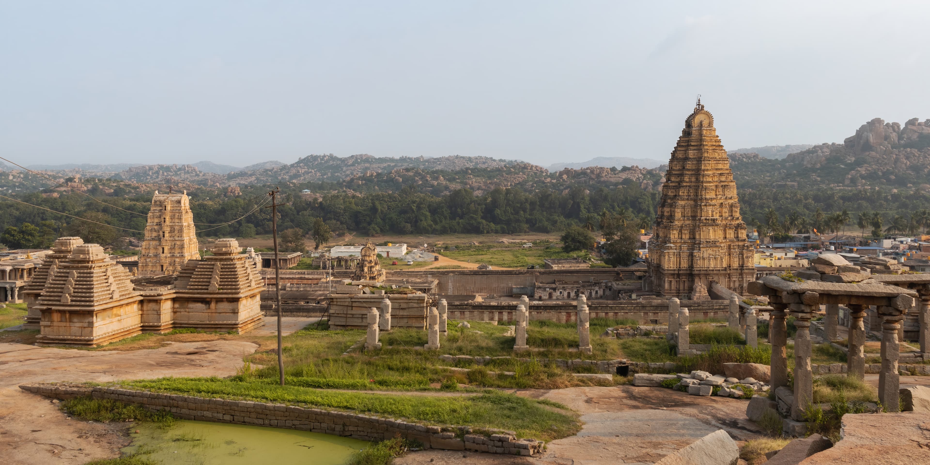
Hampi
Hampi is a safe destination by Indian standards, with violent crime toward tourists extremely rare. The primary hazards are environmental rather than human — heat stroke in summer, slippery barefoot temple steps, and monkey bites from the large Rhesus macaque population around the temples. India's overall safety index sits around 112 on global peace indices; Hampi, as a pilgrimage and tourist town, is notably calmer than urban India.
Vang Vieng
Vang Vieng is considerably safer than its 2000s-2010s reputation suggested, but outdoor adventure activities still carry real risks. The 2012 crackdown eliminated the worst excesses of the party era, but motorbike accidents, river incidents, and cave hazards remain genuine concerns. The town is calm and low-crime — the risks are environmental and activity-related, not social. Petty theft is rare.
⭐ Ratings
🌤️ Weather
Hampi
Hampi sits on the Deccan Plateau in northern Karnataka, giving it a semi-arid climate with extremes in both directions. The tourist season runs mid-October to mid-March, when temperatures are pleasant and the granite ruins are comfortable to explore on foot. The remaining months — summer heat peaking above 40°C and a monsoon that turns paths muddy — make off-season visits genuinely challenging.
Vang Vieng
Vang Vieng has a tropical monsoon climate typical of inland Laos, moderated slightly by its valley position between karst ridges. The dry season from November through April is the main visitor window — balloon flights run, caves are passable, and the Nam Song is calm. The wet season brings dramatic green scenery but floods caves, makes rivers dangerous, and can cancel outdoor activities for days at a time. March and April add a burning season smoke hazard.
🚇 Getting Around
Hampi
Hampi's ruins span roughly 26 km² — too large to walk entirely but well-suited to bicycle or scooter. The Sacred Centre (Virupaksha to Vittala Temple, ~3 km) can be done on foot. The Royal Centre (Lotus Mahal, Elephant Stables, Queen's Bath) is a further 3–4 km south, making a bicycle or hired auto-rickshaw the practical choice for covering both zones in a day.
Walkability: The Sacred Centre core is walkable but the full ruin field is not — distances between major sites range from 1 to 6 km on sandy or rocky paths. The Royal Centre is not comfortably walkable from Hampi village. A bicycle is the minimum recommended transport for visitors wanting to cover both zones.
Vang Vieng
A motorbike is essentially mandatory for getting the most out of Vang Vieng. Most of the key sights — Blue Lagoons, viewpoints, caves — are scattered 10 to 25 km from the town center on roads ranging from paved to rough laterite. The town itself is small and walkable, but the surrounding landscape is not. There is no Grab or ride-hailing. The new railway station is 3 km north of town.
Walkability: The main town center — restaurants, guesthouses, shops, the night market, and Tham Chang Cave — is compact and walkable in about 20 minutes. The bamboo bridge crossing to the east bank and Pha Ngern trailhead is a short walk from the center. Beyond town, walking is impractical — key sights are too dispersed and roads lack footpaths.
The Verdict
Choose Hampi if...
you want a UNESCO boulder-and-ruins landscape — the Vijayanagara capital, Virupaksha Temple, Stone Chariot, Matanga Hill sunset, and Hippie Island slow days
Choose Vang Vieng if...
you want a Laotian karst adventure town — dawn balloons, Blue Lagoons, rock climbing, and the new 1-hour railway from Vientiane or Luang Prabang
Vang Vieng