Yosemite National Park vs Zion National Park
Which destination is right for your next trip?

Yosemite National Park
United States
Zion National Park
United States
Yosemite National Park
Zion National Park
💰 Budget
🛡️ Safety
Yosemite National Park
Yosemite is safe from a crime perspective — property crime in parking lots is the main concern. The real hazards are natural: fatal falls on Half Dome and other high-exposure granite, drownings in the Merced River (especially Emerald Pool above Vernal Fall), rockfall, black bears raiding cars and campsites, lightning at altitude, and wildfire smoke. Yosemite averages 12-15 fatalities per year — the highest of any US national park by total count — primarily from falls and drownings. The Merced River kills multiple visitors every year. Emerald Pool above Vernal Fall looks like a swimming hole but is fed by the slick granite above Nevada Fall, and people regularly slip in and get swept over the 317-foot drop. Signs posted along the river reading "IF YOU GO OVER THE FALLS YOU WILL DIE" are not hyperbole. Half Dome's cables have killed hikers caught in thunderstorms — wet granite plus lightning is not survivable on that slope. The 2017 Royal Arches rockfall killed a climber and reminded everyone that the valley's granite walls still drop rock without warning. Black bears in the valley are highly habituated; food in a car overnight will almost certainly be broken into unless it's in a bear locker.
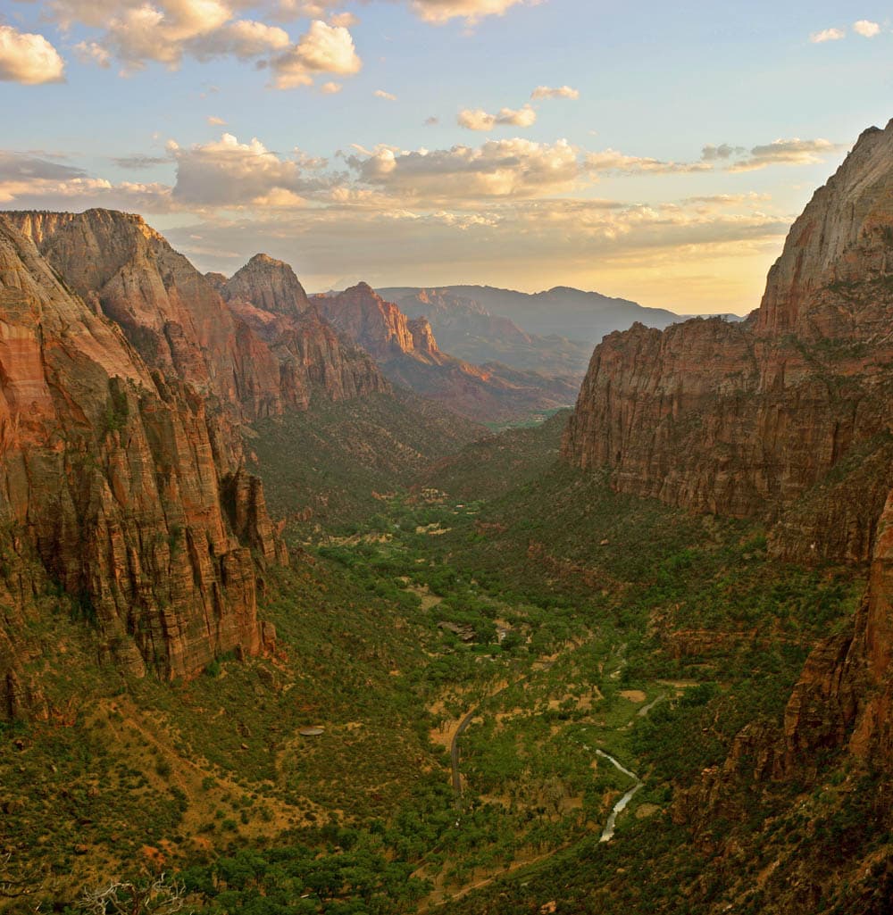
Zion National Park
Crime at Zion is a non-issue — the real hazards are natural and they kill people every year. Flash floods, falls from Angels Landing, heat illness, hypothermia in the Narrows, and dehydration are the big five. The single most important pre-hike habit: check the NPS flash flood forecast at the visitor center or nps.gov/zion before ANY slot canyon or Narrows trip. "Probable" or "Expected" risk means do not enter — a storm 10 miles upstream can kill you even in bright sunshine at the trailhead.
⭐ Ratings
🌤️ Weather
Yosemite National Park
Yosemite has a Mediterranean-to-alpine climate that is dominated by elevation. Yosemite Valley sits at roughly 4,000 feet — warm dry summers, cool wet winters with occasional snow. The high country around Tuolumne Meadows (8,600 ft) and Tioga Pass (9,943 ft) runs roughly 10°C / 18°F cooler than the valley on any given day and stays under deep snow from November through May. This elevation split means you can be in shorts in the valley and a parka two hours later. Summers in the valley are classic California — blue skies, afternoon temperatures in the high 20s Celsius, cool nights, and very little rain. Thunderstorms build in the high country most afternoons, especially in July and August, and can hit Half Dome's exposed granite cables without warning. Spring is the waterfall peak — May is the single best month for Yosemite Falls — and fall brings crisp days, turning aspens in Tuolumne Meadows, and the occasional smoky day from California wildfires farther west. Winter is spectacular in the valley but demands planning: tire chains are frequently required on park roads (posted as R1/R2/R3 restrictions), Tioga Road and Glacier Point Road close completely, and Badger Pass ski area operates mid-December through March. The valley itself rarely drops deep below freezing at night and often sees dustings of snow rather than heavy accumulation. Photographers covet the stretch from late December through February for frozen waterfalls and snow-rimmed granite.
Zion National Park
Zion's desert climate is defined by vertical relief — the canyon floor sits at 4,000 feet while the rims reach 6,500+ feet, meaning conditions can differ by 5-10°C between stops on the same hike. Summer is brutally hot on exposed trails (35-40°C) with dangerous afternoon monsoon thunderstorms and flash flood potential in slot canyons. Winter brings ice on Angels Landing and snow on the rims, with the canyon floor hovering between 0-15°C. Spring and fall are the ideal windows. The Virgin River stays a bracing 10-15°C year-round — plan Narrows gear accordingly.
🚇 Getting Around
Yosemite National Park
Yosemite is one of the very few US national parks where you can genuinely arrive and get around without a car — a rare enough claim that it's worth emphasizing. YARTS (Yosemite Area Regional Transportation System) runs scheduled buses into the park from four gateway regions, connecting with Amtrak at Merced and functioning as real public transit rather than a tour bus. Inside Yosemite Valley, a free year-round shuttle loops every 10-20 minutes between the 21 major stops — lodges, trailheads, villages, and campgrounds — and in peak summer the valley is essentially a pedestrian-and-shuttle zone rather than a drive-through. For visitors coming from San Francisco, the budget route is genuinely competitive: take Amtrak from Emeryville (connected to SF by bus) to Merced (3 hours), then YARTS into the valley (2.5 hours). Total cost is often USD 60-90 each way and avoids the parking nightmare and summer entry reservation system that plague car arrivals. For visitors who want to see the whole park (Glacier Point, Mariposa Grove, Tioga Road, Hetch Hetchy), a car becomes much more useful — YARTS only covers the main park corridors and doesn't serve the Glacier Point Road or Tioga Road high country. Inside the valley, the free shuttle is genuinely essential in summer — the parking lots at trailheads fill by 8-9am and the shuttle lets you hop between, say, Happy Isles (for Mist Trail) and Yosemite Falls without moving your car. A seasonal Glacier Point shuttle runs from the valley in summer for those without cars. There is no Uber or Lyft coverage inside the park. Cell service is spotty in the valley and absent in most of the park.
Walkability: Yosemite Valley itself is walkable and shuttle-friendly — lodges, restaurants, visitor center, and major trailheads are all within a 2-mile radius connected by paved paths and the free shuttle. Outside the valley, distances and terrain make walking between sights impractical; Mariposa Grove is a 1-hour drive south and Tuolumne Meadows is a 1.5-hour drive east. There is no rideshare (Uber/Lyft) coverage inside the park.
Zion National Park
Zion's transportation story is simple: the free park shuttle is MANDATORY on the Zion Canyon Scenic Drive April through late November — no private vehicles past Canyon Junction. The shuttle runs a 9-stop loop roughly every 10-15 minutes, takes about 45 minutes end-to-end, and stops at every major trailhead and viewpoint. Springdale (the gateway town) has its own free town shuttle connecting lodges, restaurants, and the park entrance. A private car is only useful on the main drive December through early March, for reaching Kolob Canyons (30 miles northwest, separate entrance), or for the Zion-Mt. Carmel Highway. There is no rideshare service inside the park.
Walkability: Springdale itself is extremely walkable — a linear town strung along Highway 9 with restaurants, outfitters, and lodges all within a mile of each other. Inside the park the shuttle handles the vertical distances; hiking trails are a mix of paved strolls (Riverside Walk, Pa'rus) and serious climbs (Angels Landing, Observation Point). Kolob Canyons has its own scenic drive and short trailheads but is not pedestrian-connected to the main canyon.
The Verdict
Choose Yosemite National Park if...
you want granite cliffs, waterfalls, giant sequoias, and Tunnel View — plus a real public-transit option via YARTS from San Francisco
Choose Zion National Park if...
you want red-rock slot canyons, Angels Landing's permit-lottery ridge, and the Narrows waded up the Virgin River
Yosemite National Park
Zion National Park