Charleston
United States

Yosemite National Park
United States
Charleston
Yosemite National Park
💰 Budget
🛡️ Safety
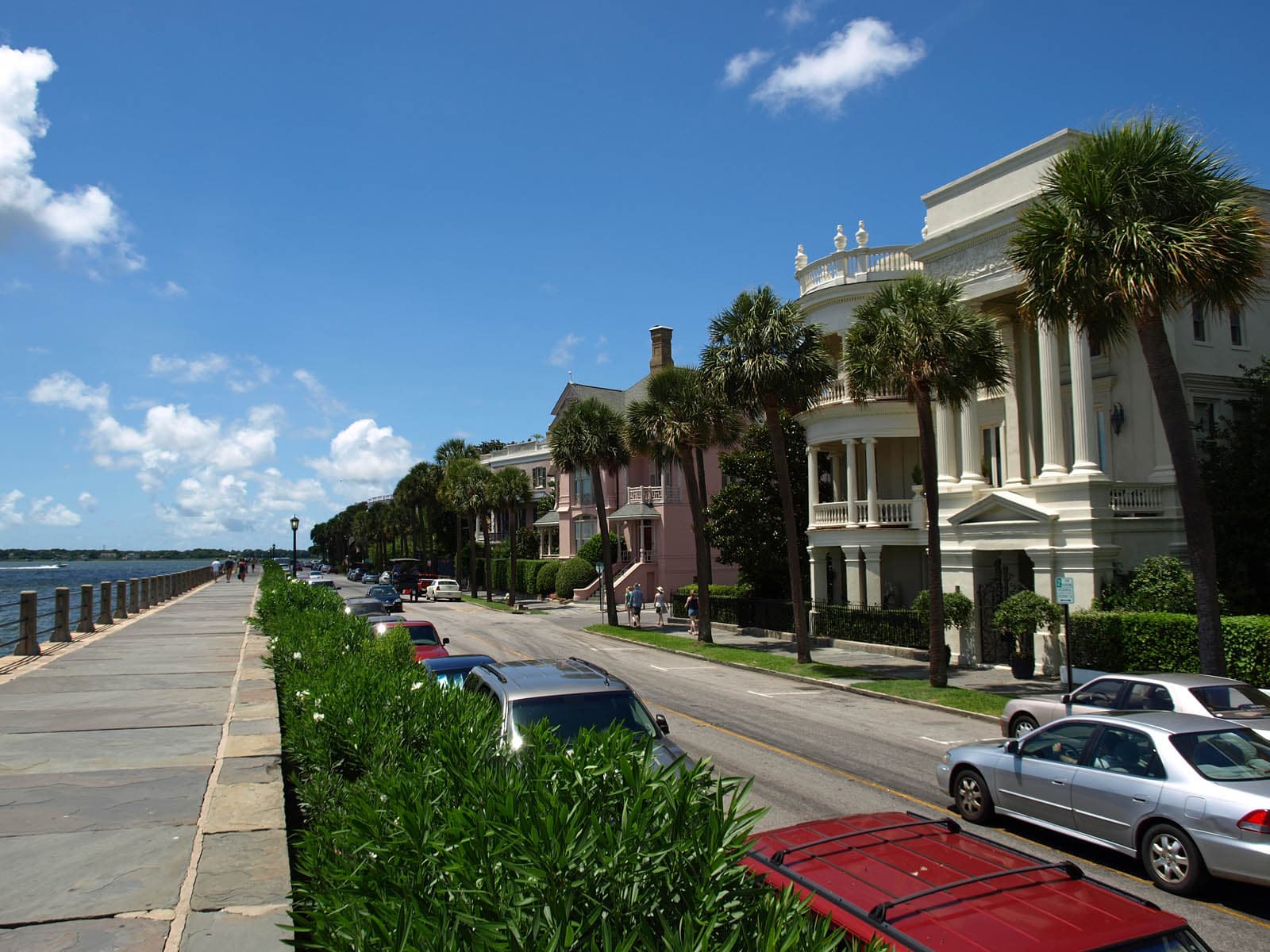
Charleston
The historic peninsula and the surrounding beach/barrier islands are very safe for visitors, with low violent crime and a heavy tourist-police presence downtown. Property crime (car break-ins, package theft) is the most common issue. Some outlying neighborhoods on the West Side and in North Charleston have higher crime rates but are not places most tourists end up.
Yosemite National Park
Yosemite is safe from a crime perspective — property crime in parking lots is the main concern. The real hazards are natural: fatal falls on Half Dome and other high-exposure granite, drownings in the Merced River (especially Emerald Pool above Vernal Fall), rockfall, black bears raiding cars and campsites, lightning at altitude, and wildfire smoke. Yosemite averages 12-15 fatalities per year — the highest of any US national park by total count — primarily from falls and drownings. The Merced River kills multiple visitors every year. Emerald Pool above Vernal Fall looks like a swimming hole but is fed by the slick granite above Nevada Fall, and people regularly slip in and get swept over the 317-foot drop. Signs posted along the river reading "IF YOU GO OVER THE FALLS YOU WILL DIE" are not hyperbole. Half Dome's cables have killed hikers caught in thunderstorms — wet granite plus lightning is not survivable on that slope. The 2017 Royal Arches rockfall killed a climber and reminded everyone that the valley's granite walls still drop rock without warning. Black bears in the valley are highly habituated; food in a car overnight will almost certainly be broken into unless it's in a bear locker.
⭐ Ratings
🌤️ Weather
Charleston
Charleston has a humid subtropical climate — mild winters, long warm springs, and punishingly hot and humid summers. Hurricane season runs June through November with peak risk in August-September. Spring (March-May) and fall (October-November) are the sweet spots.
Yosemite National Park
Yosemite has a Mediterranean-to-alpine climate that is dominated by elevation. Yosemite Valley sits at roughly 4,000 feet — warm dry summers, cool wet winters with occasional snow. The high country around Tuolumne Meadows (8,600 ft) and Tioga Pass (9,943 ft) runs roughly 10°C / 18°F cooler than the valley on any given day and stays under deep snow from November through May. This elevation split means you can be in shorts in the valley and a parka two hours later. Summers in the valley are classic California — blue skies, afternoon temperatures in the high 20s Celsius, cool nights, and very little rain. Thunderstorms build in the high country most afternoons, especially in July and August, and can hit Half Dome's exposed granite cables without warning. Spring is the waterfall peak — May is the single best month for Yosemite Falls — and fall brings crisp days, turning aspens in Tuolumne Meadows, and the occasional smoky day from California wildfires farther west. Winter is spectacular in the valley but demands planning: tire chains are frequently required on park roads (posted as R1/R2/R3 restrictions), Tioga Road and Glacier Point Road close completely, and Badger Pass ski area operates mid-December through March. The valley itself rarely drops deep below freezing at night and often sees dustings of snow rather than heavy accumulation. Photographers covet the stretch from late December through February for frozen waterfalls and snow-rimmed granite.
🚇 Getting Around
Charleston
The historic peninsula is small — about 2 miles north-to-south at its widest — and extremely walkable. Charleston has very limited public transit for a US city: CARTA buses exist but run infrequently and cover downtown poorly for tourists. Most visitors walk everything downtown and rent a car or use Uber/Lyft for beaches, plantations, and the airport.
Walkability: Charleston's historic peninsula is one of the most walkable neighborhoods in the American South — flat, shaded by live oaks, well-maintained sidewalks (some brick and uneven), and tightly packed with destinations. Outside the peninsula, however, the metro is car-dependent and pedestrian infrastructure thins out fast.
Yosemite National Park
Yosemite is one of the very few US national parks where you can genuinely arrive and get around without a car — a rare enough claim that it's worth emphasizing. YARTS (Yosemite Area Regional Transportation System) runs scheduled buses into the park from four gateway regions, connecting with Amtrak at Merced and functioning as real public transit rather than a tour bus. Inside Yosemite Valley, a free year-round shuttle loops every 10-20 minutes between the 21 major stops — lodges, trailheads, villages, and campgrounds — and in peak summer the valley is essentially a pedestrian-and-shuttle zone rather than a drive-through. For visitors coming from San Francisco, the budget route is genuinely competitive: take Amtrak from Emeryville (connected to SF by bus) to Merced (3 hours), then YARTS into the valley (2.5 hours). Total cost is often USD 60-90 each way and avoids the parking nightmare and summer entry reservation system that plague car arrivals. For visitors who want to see the whole park (Glacier Point, Mariposa Grove, Tioga Road, Hetch Hetchy), a car becomes much more useful — YARTS only covers the main park corridors and doesn't serve the Glacier Point Road or Tioga Road high country. Inside the valley, the free shuttle is genuinely essential in summer — the parking lots at trailheads fill by 8-9am and the shuttle lets you hop between, say, Happy Isles (for Mist Trail) and Yosemite Falls without moving your car. A seasonal Glacier Point shuttle runs from the valley in summer for those without cars. There is no Uber or Lyft coverage inside the park. Cell service is spotty in the valley and absent in most of the park.
Walkability: Yosemite Valley itself is walkable and shuttle-friendly — lodges, restaurants, visitor center, and major trailheads are all within a 2-mile radius connected by paved paths and the free shuttle. Outside the valley, distances and terrain make walking between sights impractical; Mariposa Grove is a 1-hour drive south and Tuolumne Meadows is a 1.5-hour drive east. There is no rideshare (Uber/Lyft) coverage inside the park.
The Verdict
Choose Charleston if...
you want pastel antebellum architecture, harbor-side history, modern Southern cuisine's spiritual home, and Gullah-Geechee heritage
Choose Yosemite National Park if...
you want granite cliffs, waterfalls, giant sequoias, and Tunnel View — plus a real public-transit option via YARTS from San Francisco
Charleston
Yosemite National Park